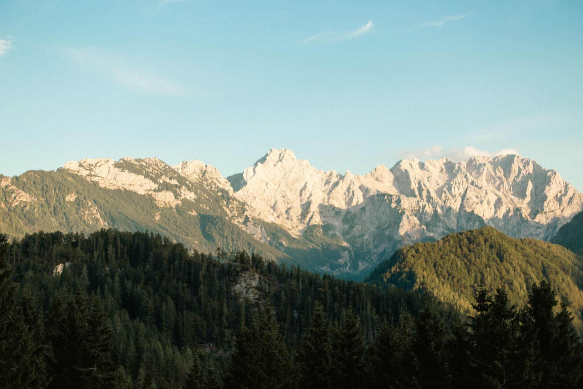
Triglav (2,864 m) is Slovenia’s highest peak, in the Julian Alps — the name means roughly “three-headed” in Slovenian, after its triple-pointed summit ridge. Every realistic route funnels through Triglavski dom na Kredarici, the high hut just below the top, before a final, unavoidably exposed ridge secured with steel cables gets you to the actual summit. It isn’t a technical climb requiring ropes or a harness, but it is a genuine two-day mountain outing with real exposure — not a casual day walk, whichever side you start from.
This is a different hike from our Triglav Lakes Valley guide — that one stays in the valley below and doesn’t touch the summit itself. This page is about standing on top. Both sit under our wider Slovenian Mountains coverage, so if you’re still deciding which of the two actually matches what you want out of a trip, it’s worth reading both before you commit.
At a Glance
- Elevation2,864 m summit; trailheads sit roughly 600–1,350 m depending on the route
- Mountain rangeJulian Alps, inside Triglav National Park
- Mountain hutTriglavski dom na Kredarici (2,515 m)
- Overall difficultyDemanding to very demanding (zahtevna–zelo zahtevna), depending on route — every route shares the same exposed final ridge
What to Expect on the Trail
Whichever valley you start from, the first few hours look similar: forest track giving way to open alpine pasture, a steady, unglamorous climb that gains real height before the mountain itself comes properly into view. Above the tree line the ground turns to scree and bare karst rock, and the routes start to diverge in character — some, like the climb out of Krma, stay gentle almost all the way to the hut; others, like the ascent out of Vrata or the Komarča cliff band above Bohinj, put in steep, cable-secured sections well before you reach Kredarica.
What every route shares is the last stretch: from Triglavski dom na Kredarici, or from Dom Planika a little lower down, a roughly 1.5-hour via-ferrata-style push along a narrow ridge, past the sub-peak of Mali Triglav, to the true summit. Steel cables and fixed pegs run along most of it, and the drop-off is real on both sides in places — this section is why the mountain has the reputation it does, regardless of which “easy” or “hard” trailhead you picked lower down. In high season it can also get genuinely congested, with hikers queuing at the narrowest points, which adds its own kind of stress on top of the exposure.
Water and shade both disappear above the tree line, so carry what you need for the day rather than counting on finding either. Rest points are the huts themselves — Vodnikov dom, Dom Planika, Kredarica — rather than anything informal on the open ridge, and most people plan their day around reaching one of them before pushing on.
How Difficulty Is Graded
Slovenia grades marked mountain trails into three official PZS categories, shown on maps and signposts as lahka pot (easy), zahtevna pot (demanding, often with secured or exposed sections) and zelo zahtevna pot (very demanding, technical alpine terrain). Trail-guide sites like hribi.net also use an informal fourth label, delno zahtevna (“partly demanding”), for a route that’s mostly easy with one harder stretch mixed in — it isn’t an official PZS grade, but it’s a fair description of a route like the lower two-thirds of the Pokljuka approach.
- Easy — lahka označena pot
Well-graded path, no exposure — describes the lower sections of most Triglav approaches, but not the summit ridge itself.
- Partly demanding — delno zahtevna označena pot
Mostly easy walking with one steeper or looser stretch — an informal label, not an official PZS grade.
- Demanding — zahtevna označena pot
Steep, often secured with a fixed cable, and exposed enough that a fear of heights matters — most of the routes below, and parts of the final ridge.
- Very demanding — zelo zahtevna označena pot
Technical alpine terrain with sustained exposure — the toughest variants (like Bamberg’s route) and, in poor conditions, the final ridge to the summit itself.
Choose Your Route
There is no single “easy way” to the actual summit — every option below ends on the same exposed ridge. Hiking times are one-way to the hut nearest the top; add roughly 1–1.5 hours from there to the summit itself.
Rudno Polje (Pokljuka) – via Vodnikov dom and Dom Planika
≈6–6.5 h to the hut area (3 h to Vodnikov dom, 2 h on to Dom Planika, then the final ridge)
Partly demanding to demanding (delno zahtevna–zahtevna pot)
≈13 km one-way, ≈1,500 m of climbing from the Rudno Polje car park (1,347 m)
Around 90% easy, well-graded walking across the Pokljuka plateau — the technical part is entirely concentrated in the final shared ridge. Widely considered the most accessible way in, which is also why it’s the busiest.
Vrata Valley – Čez Prag, to Triglavski dom na Kredarici
≈6–7 h to Kredarica
Demanding marked trail (zahtevna pot)
The standard route up the north side, from Aljažev dom (1,015 m). Includes a roughly 15 m near-vertical rock step fitted with staples and a cable — short, but genuinely a climbing move, not just a steep walk.
Aljažev dom, Vrata valley, near Mojstrana. The tougher Tominšek route starts from the same car park, a few minutes further along, if you want a more technical alternative on the way up.
Krma Valley, to Triglavski dom na Kredarici
≈7–8 h to Kredarica
Easy to demanding (lahka–zahtevna pot)
The longest of the four, but with no steep climbs or technical difficulty until the shared final ridge — a reasonable pick if you’d rather trade distance for exposure lower down.
Krma valley road end, near Mojstrana, past Dom Valentina Staniča
Stara Fužina – via Komarča and Vodnikov dom
≈7–8 h to the summit ridge area
Demanding marked trail (zahtevna pot)
The Komarča cliff band above the Voje valley is a steep, cable-secured climb in its own right, well before you reach the shared summit ridge — this route front-loads its exposure rather than saving it all for the top.
Stara Fužina / Voje, Lake Bohinj
These four cover the realistic options for a first ascent. Bamberg’s route out of Vrata, via the Luknja pass, is a genuinely harder alpine variant left off this list on purpose — hribi.net and PZS’s own route data have the full matrix if you want to see it and every other minor variant.
Getting to the Trailhead
Rudno Polje, on the Pokljuka plateau, is the easiest trailhead to reach without your own transport: it’s on a paved road from Bohinjska Bistrica, parking at the trailhead runs around €5 a day, cash only at the time of writing, and a seasonal shuttle (Line 6) runs daily from Bohinjska Bistrica in summer — check the current dates and timetable before you rely on it, since the season shifts slightly year to year. Some of the smaller forest roads further into the plateau are closed to general traffic between mid-June and mid-October, so don’t expect to drive past the main car park.
The Vrata and Krma valley trailheads, on the north side near Mojstrana, and the Bohinj-side Komarča trailhead near Stara Fužina, don’t have direct public transport to the trailhead itself — you can reach the nearby villages by bus or train and then need a car, taxi, or a fairly long walk-in to actually start hiking. If you’re doing this trip without a car, Rudno Polje is by far the more practical choice, and it also happens to be the gentlest route in.
What to Bring
- Sturdy hiking boots with real ankle support and a stiff sole — non-negotiable on the cabled sections.
- A climbing/via-ferrata-style helmet if you own one — not mandatory, but a real number of injuries on Triglav come from rockfall dislodged by other hikers above you on the crowded final ridge.
- Gloves for the cabled sections — steel cable gets cold and can shred bare hands on a long pitch.
- Enough water for the day — little to no reliable water above the tree line.
- A warm layer and rain shell — it’s genuinely cold and exposed at 2,800 m+, whatever the valley weather is doing.
- Trekking poles for the long descent, especially on loose ground.
- A headlamp, in case your day runs longer than planned.
- Cash for the hut — a card covers the online bed booking, but on-site food and drink often still means cash.
When to Go
The realistic hiking season is roughly early July through mid-to-late September, matching when the high huts are actually staffed — Triglavski dom na Kredarici’s season for 2026 runs from around early June to the end of September, but confirm the current dates directly before an early- or late-season trip. Snow can linger in the steeper gullies well into July on some approaches, particularly on the Vrata side, and conditions vary meaningfully year to year — don’t assume a route is clear just because the calendar says summer.
The final ridge is the whole story here, whichever route you picked lower down. The cables and pegs are well maintained, but the exposure is real on both sides in places, and the section gets crowded in July and August — most incidents on Triglav involve a slip on wet or crowded rock near the top, not anything that happens lower on the approach. Start early enough to be off the exposed sections before afternoon thunderstorms build, which they do quickly and often over these peaks in summer.
You’re inside Triglav National Park for the entire climb: stay on marked trails, don’t camp outside designated spots, and leave no trace. In an emergency, call 112 for Slovenia’s mountain rescue service, Gorska reševalna zveza Slovenije, and be ready to name the last marked waypoint or hut you passed — it’s the first thing they’ll ask.
The Hut
2,515 m — the last stop before the summit
Staffed roughly early June to end of September (confirm the exact dates before an early- or late-season trip)
304 beds — 108 across 31 private rooms, 196 in 16 dormitories
No dedicated winter room — outside the staffed season it’s an unheated emergency shelter only, with no food service.
Full catering in season, with roughly 300 indoor seats plus a terrace — stews, traditional dishes, and vegetarian/vegan options.
Online at triglavskidom.si, card required (Visa/Mastercard); free cancellation up to 2 days before arrival.
+386 4 531 28 64 · kredarica@pd-ljmatica.si
Dom Planika pod Triglavom (2,401 m), a smaller hut a little lower and closer to the Pokljuka approach, is a common alternative last stop for anyone doing Route 1 — worth checking if Kredarica is full in peak season.
Day Hike or Overnight?
Only realistic from Rudno Polje, and only for a genuinely fit, experienced hiker starting well before dawn — figure on 12–13 hours car to car, with no real margin for a slow start or bad weather.
Not the way most people do this mountain, and not something to attempt as your first big Slovenian hike.
The standard approach: hike up and sleep at Triglavski dom na Kredarici (or Dom Planika) on day one, then do the final ridge and summit at first light on day two, before the crowds and the afternoon weather build.
Book your bed well ahead for July and August — Kredarica is one of the busiest huts in the range.
Frequently Asked Questions
Do I need mountaineering experience to climb Triglav?
You don’t need technical climbing skills or a rope, but you do need a genuine head for heights, sure footing on loose rock, and comfort using fixed steel cables for support. It’s a serious mountain day, not a beginner’s first hike.
Is a guide required?
Not legally, but a certified mountain guide is a sensible choice if you haven’t done exposed, cable-secured terrain before — several of the sources we checked for this guide recommend one for first-timers, particularly on the Vrata-side routes.
How many days does it take?
Two, for almost everyone: up to the hut on day one, summit and back down on day two. A single-day ascent is only realistic from Rudno Polje for a very fit, well-prepared hiker.
Which route is easiest for a first-timer?
Rudno Polje, via Vodnikov dom and Dom Planika — around 90% easy walking, with the technical difficulty concentrated in the final shared ridge that every route has to cross regardless.
Do I need to book the hut in advance?
Strongly recommended, especially in July and August. Triglavski dom na Kredarici takes online bookings with a card, and beds do sell out in peak season.
More to read
Fresh from Slovenia Travel Tips
Slovenia Travel in September: Weather, Crowds, Hiking and What to Expect
A month-by-month breakdown of Slovenia in September: weather, crowds, hiking and mountain hut conditions, swimming, and the local…

Do You Need Cash in Slovenia? Cards, ATMs and When to Carry Euros
No, you don’t need to travel with a wallet full of euros. Cards and contactless work almost everywhere…
Luka Dončić’s Ljubljana: A Guide to His Hometown for Lakers Fans
This isn’t a Luka Dončić biography — it’s a practical guide to visiting his hometown of Ljubljana if…
More from Slovenian Mountains: if the summit push above isn’t what you’re after, our Triglav Lakes Valley guide covers a hike in the same national park that never touches the top. If you want something easier for the same day, our Ratitovec guide covers a gentler, year-round hike with one of the best views of the Triglav massif from outside the range itself. For an easy plateau day with none of the climbing, our Velika Planina guide covers the shepherd’s village and its cable car. Otherwise, head back to Slovenian Mountains or Destinations for the full regional overview, or pair this trip with our Lake Bohinj guide if you’re basing yourself there.

Related guides
 Velika Planina: Routes, Difficulty and the Shepherd’s Village on TopVelika Planina is a wide, high alpine pasture in the Kamnik–Savinja Alps (Kamniško–Savinjske Alpe), best known for its…
 Ratitovec: Routes, Difficulty and the Hut Famous for FlancatiRatitovec is a long, grassy ridge in the Škofja Loka Hills (Škofjeloško hribovje) with two summits close together…
 Triglav Lakes Valley: Routes, Difficulty and the Mountain HutTriglav Lakes Valley (Dolina Triglavskih jezer, also called the Valley of the Seven Lakes) is a demanding but…